
Two Worlds, One Day: Canyoneering Ropes and Packrafts on the Colorado
Rappels in the morning, packraft in the afternoon — experience Moab’s vertical and horizontal sides in one day.
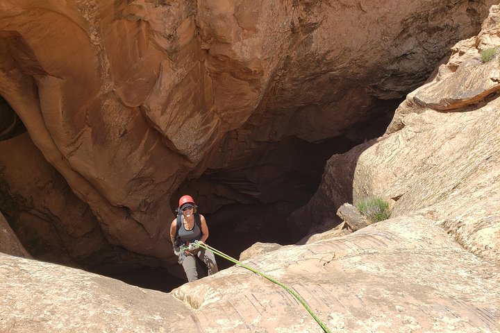
You leave Moab before sunrise and the desert is a cool thing — quiet, measured, like a held breath. Granite and red sandstone silhouette against a pale sky while your guide straps a rope to a harness and lays out an inflatable boat that folds down to the size of a duffel. By noon you'll be sliding through a slot carved by water, lowering yourself past polished walls into a canyon most people never see. By afternoon you'll be drifting in a one-person packraft along the Colorado River, the canyon opening into a long, sunlit ribbon of water. The Moab Canyoneering and Packrafting Combo is one of those single-day adventures that stitches two very different motions — vertical and horizontal — into a coherent, elemental story of this landscape.
Trail Wisdom
Arrive Hydrated
Start the day well-hydrated and carry a 1–2 liter hydration bladder; desert exertion depletes fluids quickly.
Footwear Matters
Wear grippy, close-toed approach shoes or low-volume hiking shoes that can get wet and still drain quickly.
Trust the Guide
Guides manage anchors, ropes, and river logistics — follow instructions during rappels and when entering the packraft.
Protect Electronics
Use a drybag or phone case for the float; water splashes and short swims are part of the trip.
Local Knowledge
Hidden Gems
- •A short stop at a shaded riparian switchback below the put-in where cottonwoods and tamarisk shade the riverbank
- •Small side slots adjacent to the main canyon that contain polished walls and native plant life
Wildlife
Desert bighorn sheep, Great blue heron and riparian songbirds
Conservation Note
Practice Leave No Trace, pack out all waste, and avoid disturbing vegetation along riverbanks; guided groups help minimize impact by using established access points.
The Colorado Plateau’s sandstone layers, including Navajo and Entrada formations, tell a long geologic history; Indigenous peoples and later explorers used the river corridors as travel routes.
Seasonal Guide
spring
Best for: Cooler weather for rope work, Wildflowers and green riparian zones
Challenges: Variable water levels, Occasional spring storms
Spring offers crisp mornings, ideal temperatures for rappels, and comfortable river floats, though flows can change after storms.
summer
Best for: Long daylight hours, Peak river recreation season
Challenges: High desert heat, Strong sun exposure and thermal risk
Summer delivers long days and warm water but can be uncomfortably hot; early starts and sun protection are essential.
fall
Best for: Stable weather, Warm water and cooler air temps
Challenges: Shortening daylight, Occasional cool snaps in late fall
Fall is a sweet spot: steady conditions and pleasant temperatures, making both canyon and river sections very comfortable.
winter
Best for: Solitude, Clear light and low crowds
Challenges: Cold water and hypothermia risk, Possible icy anchor points
Winter trips are quieter but require thermal protection for cold water and extra caution on slick surfaces.
Photographer's Notes
What to Bring
Approach/Trail ShoesEssential
Grip and drainage for slickrock and short swims; avoid heavy boots that retain water.
Lightweight Layering (fleece or windshirt)Essential
Temperature swings are common; layer for cool mornings and warmer afternoons.
Hydration Bladder (1–2 L)Essential
Hands-free drinking while moving and during rope work keeps hydration consistent.
Dry Bag / Phone Case
Protects electronics during the packraft float and unexpected splashes.
Common Questions
Do I need prior canyoneering experience?
No — guides teach rope techniques and manage technical sections; however, being comfortable with exposure and following instructions makes the experience smoother.
How strenuous is the trip?
Expect moderate to challenging exertion: several short technical descents, hikes, and a few miles of river float over a roughly 7-hour day.
What does the operator provide?
Guides supply canyoneering ropes, harnesses, helmets, technical anchors, and the packrafts; bring your own shoes and layers.
Is this safe for solo travelers?
Yes — trips are guided and suitable for solo travelers; groups are typically small and private options are available.
Are there age limits?
Age and weight limits can vary by operator and route; contact the guide service ahead of booking to confirm.
What happens if river levels are high?
Guides monitor flows and will adjust routes or reschedule if conditions compromise safety.
What to Pack
Hydration bladder (1–2L) for steady hydration, grippy approach shoes for slickrock and wet sections, sun protection (hat + SPF) for long exposed stretches, lightweight layers for temperature swings
Did You Know
Moab sits on the Colorado Plateau where sand dunes and marine deposits turned into iconic sandstone layers; the Colorado River helped carve the deep canyons over millions of years.
Quick Travel Tips
Fly into Canyonlands Field (CNY) or Grand Junction (GJT); arrive early to beat heat and crowds; expect intermittent cell service in canyon sections; confirm weight/age limits with the operator before booking
Local Flavor
Finish the day in downtown Moab: grab a local brew and a hearty meal at one of the town’s eateries, and check out the small galleries and outfitters that showcase regional art, route beta, and community events.
Logistics Snapshot
Closest airport: Canyonlands Field (CNY) or Grand Junction (GJT) / Driving from Moab: 10–45 minutes depending on put-in / Cell service: intermittent in canyons / Permits: operator typically manages access; check with guide for park or BLM requirements
Sustainability Note
This route uses sensitive canyon and riparian environments — pack out all trash, stick to established anchors and access points, and use biodegradable sunscreen near water.
Continue Reading

First Waves on the Grand Strand: Surf Lessons in Myrtle Beach
Learn to stand up on your first wave on the Grand Strand. Myrtle Beach’s gentle breaks and experienced instructors make it an ideal place for beginners to get comfortable on a board—and then explore the surf culture that grew around it.
Myrtle Beach, South Carolina

Chasing Cascades: A Half-Day Hike From Asheville to Waterfalls and Wildwoods
In four hours you can move from Asheville's streets into cathedral-like forest and the roar of mountain waterfalls. This guided half-day hike pairs scenic cascades with a certified naturalist to turn scenery into story.
Asheville, North Carolina