
Rappelling Into the Goblins’ Lair: A 4‑Hour Canyoneering Escape in Goblin Valley
Short rappels, hoodoo mazes and a desert classroom—an accessible canyoneering day trip in Utah’s quirkiest park.
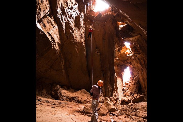
You drop from the rim into a bowl of sandstone mushrooms and alien silhouettes. Wind dents through narrow amphitheaters and the stone underfoot is warm from the morning sun; shadows lengthen and the hoodoos—locally called goblins—look briefly like a silent audience. This is not a postcard stop. It’s a playground of pockets, short rappels and low-angle chimneys that ask you to move deliberately and laugh when you recover your footing. For four hours a guide shepherds a small group through slots and slickrock corridors, pausing at viewpoints where the valley opens like a stage for the Colorado Plateau’s geological theater.
Trail Wisdom
Hydrate for desert heat
Carry at least 1 liter for a half-day in spring/fall and 2+ liters in summer—electrolyte mixes help on hot days.
Sturdy shoes, not climbing shoes
Closed-toe hiking shoes with sticky rubber give traction on slickrock and protect toes while scrambling.
Sun protection is non-negotiable
Hat, sunscreen and light layers will keep you comfortable during exposed stretches.
Trust the guide on rope work
Guides provide gear and instruction—listen during rigging demos and double-check your harness before a rappel.
Local Knowledge
Hidden Gems
- •Goblin’s Cave—small alcove network off the main amphitheater (ask your guide)
- •Sunset Viewpoint on the western rim for wide-angle desert panoramas
Wildlife
Desert cottontail, Collared lizard
Conservation Note
Stay on established paths, avoid touching fragile rock coatings, and pack out all trash—these measures protect delicate sandstone surfaces and cryptobiotic soils.
Goblin Valley’s sandstone structures are part of the Jurassic Entrada and Curtis formations; the area remained lightly settled for decades, preserving its otherworldly features.
Seasonal Guide
spring
Best for: comfortable temperatures, wildflower accents, family outings
Challenges: mud after storms, variable daytime temps
Spring offers mild days and cool mornings—ideal for a relaxed canyoneering pace but watch for muddy patches after rain.
summer
Best for: long daylight hours, early morning departures, desert contrasts
Challenges: extreme heat, limited shade, increased dehydration risk
Summer trips require early starts, lots of water and sun protection; afternoon storms are rare but possible.
fall
Best for: stable weather, rich sandstone colors, comfortable hiking temps
Challenges: heavier visitation on weekends, cooler evenings
Fall is the sweet spot—pleasant conditions and saturated reds make for great photography and comfortable movement.
winter
Best for: clear skies, fewer crowds, crisp light for photos
Challenges: cold mornings, possible icy patches, shorter daylight
Winters are quiet and dramatic, but bring warm layers and expect chilly exposed sections—rappel ropes can feel slick if icy.
Photographer's Notes
What to Bring
Hiking shoes with sticky rubberEssential
Provides grip on slickrock and protection during scrambling.
Sun hat and sunscreenEssential
Protects from intense desert sun and lowers heat stress.
Hydration bladder or bottlesEssential
Carry 1–2+ liters depending on season to avoid dehydration.
Light wind shell or fleece
Useful for cool mornings or windy exposures in shoulder seasons.
Common Questions
How long is the canyoneering trip?
The guided experience runs about 4 hours from meeting time and covers scrambling, short technical sections and at least one guided rappel.
Do I need prior rappelling experience?
No—guides teach and supervise all rope work; basic comfort with heights and following instruction is required.
What is included in the price?
Guides typically provide technical gear (harness, helmet, ropes), instruction, and park entry handling—confirm current specifics with the operator when booking.
Is this trip family-friendly?
Yes—operators advertise suitability for a range of ages, though each participant should be able to hike across uneven terrain and follow safety briefings.
Will I need a vehicle to reach the trailhead?
You’ll meet at a designated staging area; many groups drive themselves from Moab or Hanksville, but the tour operator may provide detailed meeting instructions.
What should I do about cell service?
Expect intermittent or no cell service in the valley—download directions, inform someone of your plans, and rely on your guide for logistics.
What to Pack
Hiking shoes (traction and protection), 1–2L water (hydration), Sun protection (hat & sunscreen), Lightweight layer (morning/evening chill)
Did You Know
The distinctive 'goblins' at Goblin Valley are hoodoos formed from Entrada sandstone—differential erosion of harder and softer layers created the mushroom-like shapes visible today.
Quick Travel Tips
Book the guided trip in advance (popular on weekends); start early in summer to avoid heat; bring cash or card for park fees; check weather—flash floods are rare but possible.
Local Flavor
Base your trip in Moab for the most dining and beer options—post-adventure favorites include a cold pint at Moab Brewery or a casual meal at a local café; Hanksville offers a quieter, small-town stop with basic services.
Logistics Snapshot
Closest airports: Canyonlands Field (CNY, Moab ~75 miles) or Salt Lake City (SLC ~230 miles). Driving from Moab: ~75 miles (1.5–2 hours). Cell service: spotty in the park. Permits/passes: Utah State Parks day-use fee required—confirm operator handling.
Sustainability Note
The goblins are fragile sandstone formations—do not climb on delicate hoodoos, avoid disturbing cryptobiotic soils, and pack out all trash to preserve the landscape.
Continue Reading

First Waves on the Grand Strand: Surf Lessons in Myrtle Beach
Learn to stand up on your first wave on the Grand Strand. Myrtle Beach’s gentle breaks and experienced instructors make it an ideal place for beginners to get comfortable on a board—and then explore the surf culture that grew around it.
Myrtle Beach, South Carolina

Chasing Cascades: A Half-Day Hike From Asheville to Waterfalls and Wildwoods
In four hours you can move from Asheville's streets into cathedral-like forest and the roar of mountain waterfalls. This guided half-day hike pairs scenic cascades with a certified naturalist to turn scenery into story.
Asheville, North Carolina