
Pedaling the Painted Canyon: Mountain Biking Around Tilcara
A two-hour guided loop through the ochre cliffs and terraced fields of Quebrada de Humahuaca
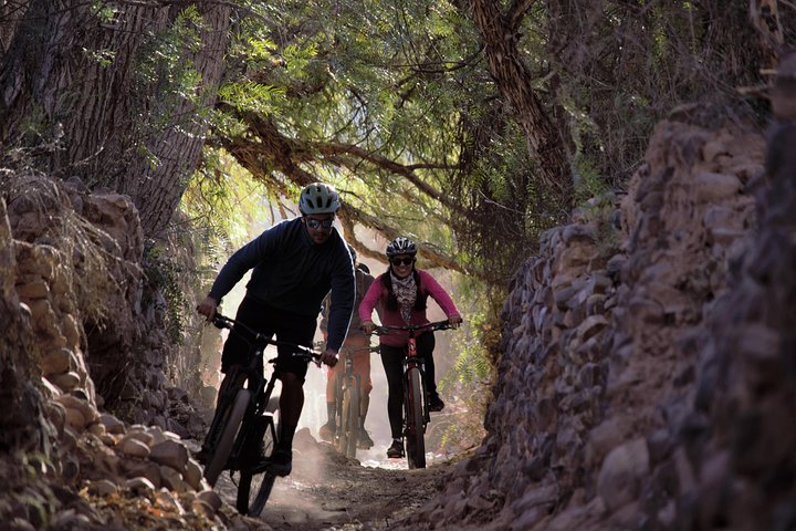
The air is thin enough to make your lungs count every revolution. At two kilometers above sea level, the world narrows to a ribbon of trail, the clack of gears, and a canyon that seems to have been hand-painted in oxidized reds, brass yellows and mint greens. You begin in Tilcara’s plaza, bikes fitted and helmets tightened, and within minutes you’re riding under a late-morning sun that throws every ridge into relief. The Quebrada de Humahuaca doesn’t whisper; it dares you to keep up. Columns of layered rock rise like pages in a geologic atlas while dry washes and terraced fields remind you this is a lived landscape — one shaped by Andean hands for millennia.
Trail Wisdom
Acclimatize first
Spend at least a half-day in Tilcara to adapt to ~2,400 m altitude before pushing hard on climbs.
Tire choice matters
Use wider, grippy tires (2.0" or larger) to handle loose gravel descents and rocky sections.
Hydrate early
Carry 1–2 liters and sip frequently — high, dry air dehydrates faster than you think.
Follow your guide
Guides know the best viewpoints and the trickier trail lines; listen for route changes due to weather or local events.
Local Knowledge
Hidden Gems
- •Early-morning visit to Pucará de Tilcara before the crowds
- •Weekend artisan market at Tilcara plaza for textiles and folk crafts
Wildlife
Andean condor, Llama / vicuña herds
Conservation Note
Stick to established trails to protect fragile highland soils, and support local guides and markets to ensure tourism benefits the community.
The Quebrada de Humahuaca has been a north–south trade and pilgrimage corridor for more than 10,000 years and was inscribed as a UNESCO Cultural Landscape in 2003.
Seasonal Guide
spring
Best for: Wildflower accents, Milder temperatures, Fewer crowds
Challenges: Variable winds, Cooler mornings
Southern-hemisphere spring (Sep–Nov) brings mild days and blooming scrub—one of the best times to ride the canyon colors without summer heat.
summer
Best for: Longest daylight, Warm days, Extended photo windows
Challenges: Afternoon thunderstorms, Stronger sun
Summer (Dec–Feb) is warm with longer days; plan for early starts to avoid afternoon storms and intense sun.
fall
Best for: Stable weather, Clear light, Pleasant temperatures
Challenges: Cooler nights, Shorter days
Autumn (Mar–May) offers clear, crisp air and excellent visibility—ideal for dramatic canyon photography.
winter
Best for: Crisp skies, Fewer tourists, Bright sunlight
Challenges: Cold mornings, Possible frost at altitude
Winter (Jun–Aug) delivers cold mornings but often crystal-clear days; layer up for chilly starts and enjoy quiet trails.
Photographer's Notes
What to Bring
HelmetEssential
Protects against falls on rocky or loose sections — non-negotiable.
Hydration pack (1–2L)Essential
Keeps water and small tools accessible at altitude and in dry conditions.
Spare tube / puncture kitEssential
Quick tire repairs minimize downtime on remote stretches.
Light windproof layer
Blocks canyon winds and cool temperatures during descents or early starts.
Common Questions
How long is the ride?
The guided loop is two hours; expect approximately 8–15 km depending on the chosen route and stops.
Do I need to bring my own bike?
No — most guided options include a mountain bike and helmet; confirm bike sizing when you book.
Is this suitable for beginners?
Yes for fit beginners with basic off-road handling; difficult technical sections are optional or walked with guidance.
What about altitude sickness?
Tilcara sits around 2,400–2,500 m — mild symptoms are possible; acclimatize by spending time in town, hydrate, and avoid heavy exertion on your first day.
Are guides bilingual?
Guides often speak Spanish and basic English; check with the operator if you require fluent English or another language.
Are permits required?
No special permits are typically required for guided mountain-biking loops around Tilcara, but protected-site entry fees (e.g., Pucará) may apply.
What to Pack
Helmet (safety); Hydration pack (1–2L for altitude); Spare tube/mini-pump (repairs on the trail); Windproof layer (chilly descents)
Did You Know
The Quebrada de Humahuaca was inscribed on the UNESCO World Heritage List in 2003 for its cultural landscape shaped by millennia of human settlement and trade.
Quick Travel Tips
Book a guided ride to get local knowledge; spend a day in Tilcara to acclimatize; carry cash for small market purchases; start rides early to avoid afternoon wind
Local Flavor
After a ride, grab empanadas and a strong coffee in Tilcara’s main plaza, browse artisan stalls for handwoven textiles, and look for local microbrews or a communal peña where musicians gather in the evening—food and music connect you directly to the valley’s living culture.
Logistics Snapshot
Closest airport: Gobernador Horacio Guzmán International (San Salvador de Jujuy, JUJ) — approx. 80–100 km / 1.5–2 hours drive to Tilcara; Typical meeting point: Tilcara plaza or arranged local pickup; Cell service: intermittent in stretches of the quebrada; Permits: none for the ride, entry fees may apply for archaeological sites; Price & duration: US$20 from operator; 2 hours (instant confirmation, free cancellation available).
Sustainability Note
Stay on established trails, avoid riding across agricultural terraces, pack out all waste, and favor locally owned guide services to ensure tourism dollars support the community.
Continue Reading

First Waves on the Grand Strand: Surf Lessons in Myrtle Beach
Learn to stand up on your first wave on the Grand Strand. Myrtle Beach’s gentle breaks and experienced instructors make it an ideal place for beginners to get comfortable on a board—and then explore the surf culture that grew around it.
Myrtle Beach, South Carolina

Chasing Cascades: A Half-Day Hike From Asheville to Waterfalls and Wildwoods
In four hours you can move from Asheville's streets into cathedral-like forest and the roar of mountain waterfalls. This guided half-day hike pairs scenic cascades with a certified naturalist to turn scenery into story.
Asheville, North Carolina